Introduction
In the wake of a wetter-than-average July, authorities in West Gippsland, Victoria, have begun dredging operations at the mouth of the Powlett River. This effort is a direct response to increased flooding across farmlands and floodplains caused by steadily rising river levels throughout the month. The project underscores the vital role river dredging plays in managing water flow, reducing flood risks, and preserving sensitive wetland ecosystems.
Rising Waters Demand Immediate Action
According to the West Gippsland Catchment Management Authority (WGCMA), July rainfall in the Powlett River catchment area exceeded historical averages, with Wonthaggi recording 119.4 mm of rain—well above the typical 97.6 mm. On July 3 alone, 26.4 mm of rain fell in a single day. These sustained high rainfall levels led to increased river flows and a gradual inundation of surrounding farmland, raising concerns among local farmers and prompting swift intervention.
Over the past five years, local residents and farmers have observed a significant increase in flooding events, with some claiming the frequency has doubled. This trend, likely driven by climate variability and changing land-use patterns, has placed increased pressure on the region’s natural water systems.
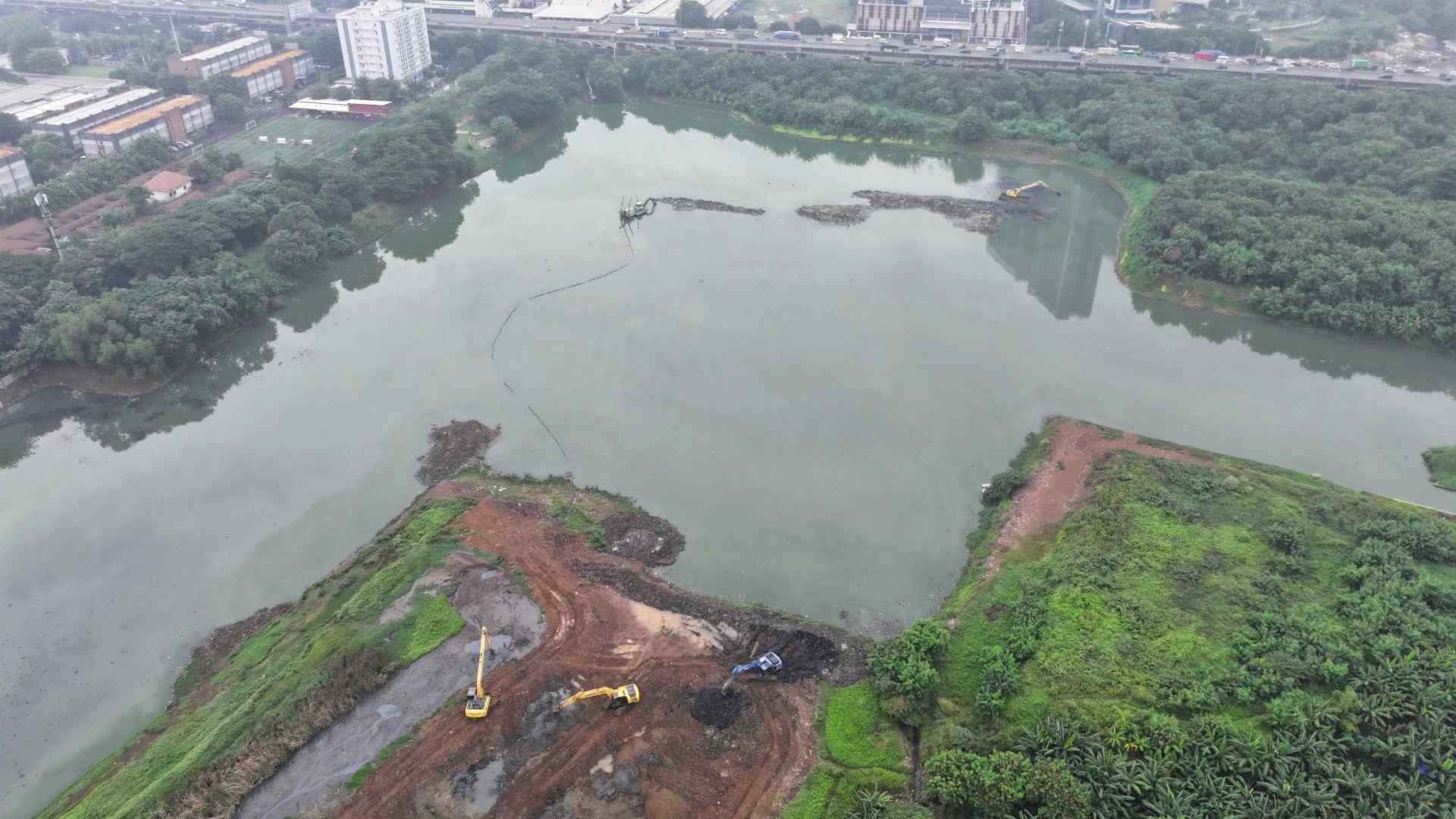
To relieve this pressure and reduce further damage, the WGCMA, in coordination with Parks Victoria, has moved to open the estuary mouth of the Powlett River to the sea. This river dredging project is designed to ease the backlog of water upstream, allowing it to drain more freely into Bass Strait.
Understanding River Dredging
River dredging is the process of excavating and removing sediment, debris, and vegetation from riverbeds, estuaries, and other water channels. Over time, sediment accumulates in these natural systems, reducing their depth and capacity to carry water. In periods of heavy rainfall, this decreased capacity can lead to overflow and flooding of adjacent areas, particularly low-lying farmland and wetland zones.
By dredging the mouth of the Powlett River, authorities aim to improve the hydraulic connection between the river and the sea. This will not only lower upstream water levels but also help protect nearby ecosystems that are sensitive to prolonged inundation.
Strategic Decision-Making Backed by Data
The decision to open the estuary mouth wasn’t made lightly. It was informed by the Estuary Entrance Management Support System (EEMSS), a decision-making tool that integrates real-time monitoring, historical data, and input from local stakeholders. The EEMSS considers environmental, cultural, and economic factors to ensure that dredging efforts are both effective and sustainable.
On-site monitoring at the Powlett River provides ongoing data on water levels, sedimentation, salinity, and wildlife activity. This comprehensive approach allows authorities to strike a balance between immediate flood relief and long-term ecological stewardship.
Protecting Bunurong Country and Local Ecosystems
The Powlett River estuary, also known as Kugerungmome, lies on Bunurong Country and is recognized as a dynamic wetland ecosystem. It provides essential habitat for numerous plant and animal species, some of which are rare or threatened. The estuary’s health is intimately connected to the broader environmental well-being of the region.
Uncontrolled flooding can have severe impacts on this delicate ecosystem. Prolonged inundation can alter vegetation patterns, affect breeding cycles of fish and birds, and increase the risk of pollution from runoff. Carefully managed dredging helps mitigate these risks by restoring natural water flow and improving the resilience of the wetland.
Additionally, cultural heritage values must be respected. Local Indigenous communities are often consulted during such projects to ensure that significant cultural sites and traditional practices are protected during and after dredging activities.
Supporting Local Agriculture
Agriculture is a cornerstone of the West Gippsland economy. The farmland along the Powlett River supports a variety of crops and livestock operations, many of which are vulnerable to waterlogging and soil degradation caused by flooding. When fields are inundated, crops fail, livestock are displaced, and long-term productivity suffers.
Dredging, in this context, offers both immediate and future-oriented benefits. In the short term, it prevents further loss from standing water. In the long term, it reduces the frequency and severity of such events, giving farmers a more predictable environment in which to plan and operate.
A Model for Adaptive River Management
The Powlett River dredging project exemplifies how targeted, data-driven interventions can address the challenges posed by extreme weather and changing climate patterns. As such events become more frequent across Australia and the world, communities will need to adopt more flexible and proactive water management strategies.
Adaptive management practices, such as those employed by WGCMA, rely on continual learning and community involvement. Rather than waiting for disaster to strike, these methods use real-time data, scientific modeling, and stakeholder feedback to anticipate issues and implement solutions before they escalate.
Conclusion
The dredging of the Powlett River mouth is more than an emergency response—it is a demonstration of how environmental engineering and careful planning can come together to safeguard communities, farmland, and ecosystems. As rainfall patterns shift and flood risks increase, river dredging will continue to be an essential tool for regions like West Gippsland, providing relief today and resilience for tomorrow.